Monday, September 7, 2009

Future Fred at Sea: Looking Closer to Home


The tropical wave in the east Atlantic, 96L Invest, continues to organize and may be upgraded to a depression at 5PM EDT. 96L will likely strengthen into a tropical storm and potentially our second hurricane of the season. Model guidance is not backing off on the idea of quick recurvature out to sea ahead of an oncoming trough. "Fred" is not expected to pose any threat to landmasses.

A weak area of low pressure off the Carolina coast is not expected to strengthen. Upper air conditions are not favorable. Of slightly more interest is the potential lowering of surface pressures in the Gulf of Mexico in 5-7 days. No models are showing tropical cyclone formation, but they do suggest that this could be an area to watch down the road. Upper air conditions should become slightly more conducive ahead of an approaching cold front that will approach the upper Texas coast in about 6 days. The favorable pulse of the Madden Julian Oscillation will also be entering the western portion of the Atlantic basin around this timeframe. The models are keying in on the Bay of Campeche and southwest Gulf the most. Any low pressure that forms in this area has a better chance of lifting north rathern than drifting into Mexico.

Sunday, September 6, 2009

Fred on the Way; No Threat


A strong tropical wave (96L Invest) has exited the African coast within the last 24 hours. Nearly all dynamical guidance (CMC, GFS, ECMWF, UKMET) shows intensification into a strong tropical storm or hurricane. The Hurricane Center has given it a 30-50% chance of development within 48 hours. Water vapor imagery reveals a very favorable environment with plenty of moisture and upper ridging aloft, thus little shear. 96L will likely become "Fred" in the coming days, but all models show recurvature into a weakness in the Atlantic subtropical ridge. This tropical system poses no threat to land.

Saturday, September 5, 2009

No Threats in Forseeable Future

The remnnant of Erika is showing no signs of organization and the tropical waves in the east Atlantic look much of the same. The east Atlantic waves has some chance of development, but they are also good candidates for recurvature well away from any landmasses. The tropical Atlantic will get another look tomorrow or Monday, but for now all is quiet.

Thursday, September 3, 2009

Erika Degenerates into Depression

As of 5PM EDT the National Hurricane Center has downgraded Erika to a tropical depression. This comes as no surprise given the high shear and dry air that has been talked about the past few days. Upper air conditions are expected to remain unfavorable across the Caribbean. Furthermore, the weak center will have to contend with mountainous Hispaniola. Erika will likely degenerate into an open wave. Nevertheless, Erika's remnant will continue to be monitored as it heads toward the Bahamas.

Elsewhere, model guidance suggests that 1-2 tropical cyclones may form from tropical waves about to exit the coast of Africa. The models also depict a vigorous trough in the central Atlantic. This trough would quickly recurve any tropical systems that quickly strengthen in the east Atlantic.

Wednesday, September 2, 2009

Erika Remains Weak

Tropical Storm Erika is having major issues with southwest shear being generated by the subtropical jet across the Caribbean. Erika will have to contend with this jet axis for at least the next several days. Little development or even dissipation is possible, especially if the center crosses the high terrain of Hispaniola. Most guidance continues to take Erika north of Hispaniola, but there has been a westward trend with time. The models that intensify (incorrectly) the storm are indicating recurvature in the west Atlantic whereas the models that keep Erika weak show a continued west-northwest motion. The official forecast from the Hurricane Center continues to follow a blend between both scenarios.

The current thinking here is that Erika will remain a weak depression/storm or possibly even open into a strong tropical wave as it rides along the Great Antilles. A weaker, low level-controlled, system will not feel the effects of the trough in the mid levels as much as a more intense storm. In the medium range, Erika or its wave axis could travel as far west as the Florida peninsula or eastern Gulf before being pulled north by a secondary trough. This forecast will verify only if Erika remains weak. Otherwise, the more northerly tracks will verify. Finally, it is too early to determine if conditions will be favorable for intensification or redevelopment once near Florida.

Monday, August 31, 2009

Hurricane News around the Web

Monthly tropical cyclone activity in the northern hemisphere ended slightly above average last August. Northern hemisphere activity still remains well below average for the year. Click here for the details.

Storm chasers are in Baja California awaiting the arrival of major hurricane Jimena. Follow their progress here.

A member of the Eastern US Weather forum is also chasing Jimena. Follow the thread.

No Need to Fright Over 94L Yet

94L certainly continues to look better than it has the past few days. A well defined surface circulation is still lacking however. That was the main emphasis in the afternoon outlook from the National Hurricane Center. Conditions are marginally favorable for slow development the next couple days. Even if Erika forms soon, no rapid intensification is expected at least over the next 5 days. An unfavorable upper trough (enhanced by El Nino) located over the Greater Antilles wil not move much at all. Wind shear over the disturbance will probably increase as a result.

94L should be near or north of Hispaniola by Saturday morning. If it unexpectedly becomes a more potent storm by then, it will be more likely to recurve into a trough over the west Atlantic. If 94 remains generally weak, then it will likely remain embedded in low level easterly flow for an extended period. Thereafter, high pressure would build over the East coast and push the disturbance toward the Florida peninsula. It is too early to say whether conditions would be more favorable for development by the time it reaches the Bahamas if the second scenario pans out.

There's a lot of questions remaining but there's a lot of time for them to be answered. 94L isn't expected to do much of anything too terribly fast. Elsewhere, the tropics are generally quiet. The GFS and ECMWF models have been depicting a strong wave exiting Africa within the next few days. It may exit Africa at a very high latitude, however, resulting in a higher chance of recurvature whether it develops into a storm or not.

94L Organizing Quickly

A tropical wave in the central Atlantic (94L INVEST) is organizing and could easily be classified a tropical cyclone withint the next 24 hours. 94L has been structurally sound the past 36 hours, but convection has been lacking near the low level circulation. The trend has apparently ended this morning, with thunderstorm activitiy consolidating right over a developing surface circulation. Upper level winds appear favorable for steady intensification at least in the short term. Two upper lows to the west and north, respectively, are far enough away from 94L to enhance the favorable ridging directly over it. 94L should remain on a general west-northwest heading over the next few days. 94L will pass at least very close, if not directly over, the northeast Caribbean within the next few days. Interests there should follow the latest updates from the National Hurricane Center.

As stated before, conditions at least in the short term look favorable for intensification. Whether those conditions persist over the next 5-10 days may determine if 94L is a threat to the Southeast USA. A pattern change is underway. East coast and New England ridging will slowly replace the East Coast troughing that has been in place for the past couple months. The ridging should encompass much of the west Atlantic and southeast by the time 94L makes it to those areas further south. 94L should remain on a west to WNW heading under the ridge.

Saturday, August 29, 2009

Next?

Danny has become extratropical and the majority of the worst weather is remaining off the New England coast. 94L is still being monitored in the central Atlantic but it's not looking overly impressive. Other than the CMC model, it doesn't have much model support. There's not much else in the basin at this time.

Despite the relative slow season, a moderate burst is likely at some point next month as we inch closer to the climatological peak of hurricane season. The US mainland and surrounding areas also aren't out of the woods. Some of the slowest hurricane seasons on record still produced destructive landfalling major hurricanes. The annual seasonal forecast released in late May called for a more favorable US landfall pattern come September. The synoptic pattern was forecast to transition, with a ridge taking shape across the US Eastern seaboard, New England, and southeast Canada. Several GFS ensemble members are showing this pattern taking shape as we enter the first week of September.

Thursday, August 27, 2009

Forecast Philosophy Unchanged

Tropical Storm Danny continues to be hindered by strong southwest shear. For that reason, Danny remains assymetrical with most convection northeast of the exposed circulation. Furthermore, additional center relocations are expected. One relocation already transpired overnight. The National Hurricane Center had to reposition their coordinates 80-90 nautical miles to the north-northeast between the 11PM and 5AM advisories.

The following is a summary as to how this atmospheric process works: Organized convection is essentially a large mass if rising air evacuating from the surface. This causes surface low pressure to form. Air from surrounding areas begins to fill the void left at the surface, hence the formation of a new circulation.

Afternoon visible imagery for a 2nd day in a row shows the beginning stages of center relocation to the northeast. Any additional repositioning to the northeast will further diminish the direct landfall threat to the USA. Forecast guidance has a better handle on the steering mechanisms than the exact position of the tropical cyclone, meaning that subtle changes in storm location will most alter the forecast path from this point onward. There's still an even number of models that take Danny into the Mid-Atlantic States and New England as there are models that recurve Danny into Nova Scotia. The expectation of more center relocations continues to make Nova Scotia landfall the more likely solution.

The intensity forecast guidance that strengthens Danny into a hurricane are still believed to be suspect. Water vapor imagery shows multiple upper lows in the western Atlantic and southeast US. The presence of these features do not bode well for that much strengthening. Conditions may become somewhat favorable for slow development into a modest 55-65mph storm once between 35N and Nova Scotia. Danny will also be acquiring extratropical characteristics by this time. It should be noted, however, that the official forecast still calls for Danny to become a Category 1 hurricane.

If the center of Danny remains just east of the US (current thinking), then effects in the Mid-Atlantic and New England would be minimal. Keep in mind that the strongest winds and rain should be confined to the eastern semicircle of the storm (offshore).

Elsewhere, the NHC has given a tropical wave in the central Atlantic a 30-50% chance of development within 48 hours. Some slow development is possible, but only one model is overly agressive at this time. The wave is still at least a week away from any landmasses.

Wednesday, August 26, 2009

Danny - East Coast or No Go?

Tropical Storm Danny was upgraded at 11AM eastern, but the surface circulation remains exposed well to the west of the most concentrated thunderstorm activity. The shear-causing upper lows remain near Danny, and they will stay in the area through the forseeable future. The official forecast makes Danny a borderline Category 1 hurricane before it becomes extratropical as it nears landfall near New England or Nova Scotia. That forecast is in agreement with the intensity model consensus. That said, given water vapor trends, it is hard to fathom conditions becoming very conducive within the next few days. A moderate 55-65mph tropical or subtropical storm prior to extratropical transition may be more likely.

Half of the models show Danny making landfall along coast North Carolina and riding north into New England whereas the other half remain offshore. If anything, the model consensus has shifted east some today. The NHC forecast shifted to the right by a few miles between 11PM and 5PM. Furthermore, Danny's current structure would suggest that any future shifts in track would have an eastward tendency. Weak and exposed surface circulations often relocate closer to the most concentrated convection; complete reformation can commence on occassion. In this case, the center may shift further north and east. The final visible frames for this evening evening hinted at this scenario already being underway. Danny should remain just off the US eastern seaboard, but this is not the time to let one's guard down. The Canadian provinces should anticipate direct impacts.

Danny Arriving Later Today?


92L INVEST, the tropical wave in the western Atlantic, is strengthening this morning. Yesterday, NHC recon aircraft flew into the wave and found tropical storm force winds but no well defined surface circulation. This morning's visible imagery suggest that found tropical storm force winds (due to persistence of yesterday's convection) AND a surface circulation are now present. Therefore, it is likely that the National Hurricane Center will upgrade 92L to Tropical Storm Danny later this morning or afternoon. Overall, however, conditions still aren't favorable for any rapid strengthening. The strongest convection and winds remain well northeast of the center due to southwest shear. The upper level lows responsible for the shear should remain in close proxmity to 92L.

Overnight model guidance came into better agreement with a track remaining barely east of the Carolinas with only a couple exceptions. A persistent trough is still expected to recurve 92L just east of the Carolinas, but interests in this area are far from being in the clear. Any slight deviation to the left of the model tracks would place the storm right over the Outerbanks. Furthermore, there is equal uncertainty as to whether the storm system will continue due northward into the Mid-Atlantic and New England states. Even if it did, the storm may be subtropical or extratropical as it merges with a frontal period by that time. There's still a few days remaining to sort the forecast out and interests from North Carolina to the oceanic territories of Canadia need to keep up with the official forecasts.

Tuesday, August 25, 2009

Watching the West Atlantic


First, i'd like to apologize for the lack of updates. A recent illness has put the blog out of commission for a while. There's no set schedule for updates, but it still hasn't been updated as much as i'd like.

92L has formed north of Puerto Rico. Several models are showing 92L developing into a tropical storm or minimal hurricane over the coming days. However, rapid development is unlikely due to the fact that moderate southwest shear is unlikely to significantly weaken. The culprit behind the shear are two upper lows just to the west of 92L's wave axis. The upper level lows will remain in relative close proximity to 92L through the period. 92L should become the next named storm of the season, but a hurricane is probably unlikely given the only marginally favorable upper winds.

There's some disagreement among models in regards to the track of 92L. The GFS shows recurvature away from the US East Coast and landfall along Canada (ala Bill). to the contrary the UKMET, CMC, and ECMWF have it making landfall in NC and then moving northward. The models do agree on the overall pattern in which a broad trough over the eastern US will eventually induce a northerly turn. Perhaps the greatest cause for disagreement is where the models first develop a low center. The UKMET, CMC, and ECMWF develop the low further south and west than the GFS, which would make sense given there aforementioned track forecasts.

So which model solution has the better chance of verifying? In light of satellite trends, the GFS solution looks more probable. Visible satellite imagery confirms that the strongest low level inflow is setting up along the northern end of the inverted "V" of the wave axis. This is typically the area where low pressure tends to form. A surface low is expected to form somewhere near 25N/65W, which is well north of where all of the western model tracks have it.

Summary: "Danny" is expected to form within the next few days. Our best initial guestimate is a track remaining just east of the US, but Canada gets struck as it begins to acquire subtropical characteristics. Nevertheless, all interests from the Carolinas, northward should monitor the latest updates from the National Hurricane Center. The East Coase is not safe this early in the game, nor should strengthening into a hurricane be entirely ruled uout.

Sunday, August 16, 2009

Tropical Storm Warning - FL Panhandle

Tropical Depression 4 has formed in the eastern Gulf of Mexico. TD4 is expected to become a moderate tropical storm (Claudette) before coming ashore between Pensacola and Apalachicola, FL within 24 hours. TD4 formed along the northern edge of the tropical wave axis we've been following across the Caribbean/west Atlantic for the past week. Little development was expected from this wave, but a low pressure center formed along the northern extent of it as it emerged from the FL peninsula. Upper winds and water temperatures are very favorable for development. Luckily, the window of oppurtunity is very small. The primary threat will be heavy rain, an isolated weak tornado east of the center, and dangerous rip currents.

91L Forms, Ana Struggles, Bill Organizaing

Quick notes:

91L Invest has formed form a tropical wave in the southeast Gulf. This is the same wave we forecast would enter the Gulf over the past week. The models generally didn't do much with this system, nor did we anticipate more than some Gulf Coast rain from it. That said, a low is trying to form just west of Tampa tonight. Convection is firing near the center, and given persistence, a surface circulation could be present by tomorrow morning. 91L has roughly 24 hours to develop into a depression or named storm before making landfall between Mississippi and Apalachicola. Heavy rain and dangerous swimming conditions will remain the highest threats.

Ana continues to struggle under strong westerly shear. The global models continue to do next to nothing with the storm. But as we see from 91L, the lack of model support doesn't mean any storm should be entirely written off. Ana should continue to struggle with the shear, not to mention the possibility of it crossing over the high mountains of Hispaniola. Little strengthening is expected until it enters the southeast Gulf in 5 days and by then there may not be anything left of the storm.

Bill is ready to make a run at hurricane status by the looks of his satellite appearance. The models have done quite well with their correct assumptions of favorable conditions for intensification. Bill will likely end up reaching major hurricane status. The good news to report is that many of the models are trending toward the original ECMWF solution of recurvature north of the islands and out to sea (barring Bermuda). The GFS and CMC are no longer showing tracks straight through the Caribbean. By no means should residents in the Caribbean breathe a sigh of relief yet. Continue monitoring this storm!

Friday, August 14, 2009

Quick Afternoon Update on Invest 90L


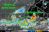
9:45 PM EDT Update: TD2 is back. Advisories will likely be reinstated either tonight or early in the morning. An image of both developing cyclones has been posted.

Invest 90L is still having some difficulty organizing, although it maintains a large and healthy low-level circulation. Slow development is expected to occur over the next few days, followed by a quicker pace of intensification once the system has fully consolidated.

The main reason to update, however, is the new data from the 12z models. The GFS has not changed its tune, and continues to show a significant tropical cyclone bearing down on the Windward Islands and then Puerto Rico and Hispaniola at days 5 and 6. The CMC has shifted northward and now takes the strong system just north of the Caribbean islands during the same timeframe. On the other hand, the UKMET has shifted slightly south and faster, taking it on a similar trajectory as shown by the GFS. The tropical model GFDL has also shifted south, while its counterpart, the HWRF, continues to insist on a track just north of the islands. Finally, the ECMWF has also shifted a little bit south from its extreme outlier solution, although it keeps it on a path well north of the Caribbean islands.

As discussed in the past few posts, the ECMWF is likely too slow with the system in the near-term. Such a slow forward speed would allow it to more notably feel the impact of a passing weakness in the subtropical ridge. A faster speed would mitigate any poleward component necessitated by the weakness. Given the current forward speed and synoptic pattern, the GFS and UKMET are the favored solutions. In fact, it would not be surprising to see the track shift even further south, as the models may be overintensifying the storm in the near-term.

Therefore, the threat to the eastern Caribbean islands has only grown stronger. Residents in this area are advised to closely monitor the progress of the developing system.

Fri Morning: ECMWF Model vs Model Consensus


The strong tropical wave south of the Cape Verde Islands (90L INVEST) continues to show signs of slow organization this morning. It takes a bit longer for such large waves to consolidate. There's still every reason to expect a significant hurricane by the time it makes it into the central Atlantic. Model guidance continues to show hardly any wind shear and the unfavorable Saharan Air Layer will remain well north of the developing storm system. The SHIPS hurricane intensity model brings 90L near major hurricane (Category 3) status by Tuesday night. The GFS, CMC, ECMWF, and UKMET all continue to indicate a very significant hurricane.

Major disagreement among the models regarding 90L's future track still exists. The CMC, GFS, and UKMET all show a major hurricane barreling into the northeast Caribbean on Wednesday give or take 24 hours. However, for the 3rd consecutive run, the ECMWF is recurving 90L away from the Caribbean and out to sea. The model is detecting a central Atlantic weakness in the subtropical ridge strong enough to turn 90L north. The other models are not as pronounce with the troughing during that timeframe. The ECMWF is a major outlier, but it wouldn't be the first time it has beaten the remaining model consensus. Interests in the northeast Caribbean should hope the ECMWF is correct, but also prepare in case the turn doesn't occur. There may be better model agreement once the new guidance comes out this afternoon. Stay tuned.

It cannot be said with 100% confidence whether 90L will miss the central Atlantic trough. Therefore it has been decided not to bring US threat scenarios into discussion at this time.

Elsewhere, the remnant of Tropical Depression Two will soon be torn apart by westerly shear of the western Atlantic. The tropical wave approaching Florida and the Gulf of Mexico will encounter similar conditions.

Thursday, August 13, 2009

TD2 hangs on, but the focus is on Invest 90L


Tropical Depression 2 is hanging on for dear life today. Latest visible satellite imagery indicates that the low-level circulation remains intact. A small area of thunderstorms is firing just to the west of the circulation and has gained some coverage over the past few hours. However, strong easterly shear is keeping the convection from covering and wrapping around the circulation. Such an unfavorable environment is expected to persist over the next several days, so little intensifcation is expected. In fact, the global models all continue to weaken the system into an open wave. This will probably occur, although it may take a few days for the circulation to completely wind down. In any event, the depression or its remnants will continue to move westward and may bring some showers to the northeast Caribbean islands early next week.

The bigger story continues to be the tropical wave and its accompanied broad area of low pressure behind TD2, now formally designated Invest 90L. This low does not yet have organized deep convection, although it has fairly impressive upper-level outflow, particularly in the southern quadrant. Moreover, conditions ahead of this system are much more conducive than what TD2 faced, partially because TD2 itself has cleared a path for a more moist environment behind. Additionally, Invest 90L is further south, so not only will it face warmer ocean temperatures and heat content, but it will also encounter less shear and dry air. Not surprisingly, all of the noteworthy global models are showing this becoming a significant tropical cyclone over the next seven days, including the typically conservative UKMET.

Of course, the main concern will be in the future track. The system is currently being steered westward by a mid-level high pressue. This feature will remain the dominant steering mechanism for the next three days. Afterward, global models indicate that a high-latitude trough will dig between the Maritimes and Azores and erode some of the ridge across the north Atlantic. This will likely induce a more northerly component to the system's movement. How much of a northerly component occurs is still in question, and depends largely on how far west the system is at the time of the ridge erosion. The GFS and ECMWF, the two more reliable global models, represent the two extremes in forward motion over the next week. The GFS shows a quicker motion, and thus the system only bends just a little to the west-northwest. As a result, the cyclone impacts the northeast Caribbean islands in seven days. The ECMWF, on the other hand, shows a very slow forward motion in the next 48 hours, which allows it more time to feel the influence of the trough. The ECMWF therefore takes it well north of the Caribbean islands. The CMC and UKMET lie in between these two solutions. Given the current forward speed of the system and the synoptic flow already in place, the GFS solution is probably closer to reality than the ECMWF solution. Tropical cyclones in this area in recent years also tended to move slightly quicker than the model consensus. Therefore, a track very close to the northeast Caribbean islands toward late next week is the favored scenario at this time. Residents of the Lesser Antilles, as well as Puerto Rico and Hispaniola, are advised to closely monitor the progress of this developing storm.

It is difficult to pinpoint where the cyclone will track beyond the seven-day timeframe. However, there are some important clues to note. The GFS ensembles, the operational GFS, and the operational ECMWF all agree on an anomalous trough to set up over the eastern US beginning around day 7. In fact, they have all consistently showed this feature for the past several days, so confidence is high that there will be a trough over or near the eastern US at the end of next week. Moreover, they are also in agreement on locking the trough in place, with very little progression by day 10. There is some discrepancy on where exactly the trough sets in, and how much ridging builds downstream. These details will be crucial in determining where the said tropical cyclone tracks in the long-range. The position of the tropical cyclone itself in seven days will also be important. In any event, the system will probably recurve at some point due to the trough. Over the coming days there will hopefully be a better and more concise grasp on the system's future.

Morning Guidance: High Uncertainty Remains


This morning's guidance hasn't solved much. If anything they only beg to ask more questions. This shouldn't come as much of a surpise though since we're dealing primarily with two tropical systems that are still very far out in the Atlantic.

Tropical Depression Two is evidently struggling significantly this morning. TD2 came close to reaching tropical storm status briefly yesterday afternoon, but has been on a downward spiral ever since. A combination of continued easterly shear, dry air entrainment from the northeast, and marginal water temperatures have really put a hamper on the depression. The easterly shear will soon be replaced by westerly shear along the central Atlantic subtropical jet axis. There's still an outside chance we may see gradual intensification over the next few days, but dissipation is more likely. Nevertheless, TD2 or its remnant will be monitored for any sign of regeneration as it heads toward the west Atlantic. This morning's guidance now shows a decent model consensus of a track toward the US East Coast. A weaker tropical system is harder to be picked up by mid to upper level troughs in the western Atlantic.

The much talked about tropical wave behind TD2 is now directly south of the Cape Verde Islands. Early morning infrared imagery shows that convection is on the rise. Gradual organization should commence as conditions remain favorable for development. TD2 is moistening up the atmosphere ahead of the system and shear is minimal. The GFS, ECMWF, CMC, and now the UKMET all suggest that a significant hurricane will be treking across the central Atlantic over the next 5+ days. Furthermore the GFS, CMC, and UKMET all agree that the hypothetical hurricane will be bearing down on the Lesser Antilles by Tuesday night and Wednesday morning. However, for whatever reason the ECMWF is showing a much slower storm with the closest time of approach being Wednesday night and into Thursday. The morning run of the ECMWF is also the furthest north, keeping the storm north of the islands. While the ECMWF solution would be good news for the Caribbean, it does seem suspect since it has no support from the other aforementioned models. The more northerly track is also questionable because the ECMWF itself doesn't show much in the way of a weakness in the high to the north. Regardless of current guidance, interests in the northeast Caribbean should expect to be within the cone of error in coming days. It would be wise to get an early start to preparations just in case the storm does in fact pass through the islands.

There's too many variables to attempt to assess the US threat at this time. Elsewhere, the wave that will be over the Gulf this weekend is nearing the Bahamas. Convection is still flaring this morning, but upper winds are not favorable. None of the models do much with this system. Nevertheless, tropical downpours will be on the rise as the wave axis approaches.

Wednesday, August 12, 2009

TD2 Paving Way for African Wave


I just wanted to quickly share with you guys the following moisture animation. TD2 is acting as kamakazee frontrunner by diverting all of the African dry air away from the strong tropical wave behind it. The African wave has ample moisture to work with. The image is courtesy of CIMSS

CIMSS Precipitable Water Animation

Additional Thoughts


The previous blog left out any talk about the weekend Gulf mischief but the details are still worthy of discussion. The tropical wave that will increase rain chances along the Gulf Coast during the late weekend and into next week is passing over the Lesser Antilles. Convection has been enhanced this afternoon due to some westerly shear and an upper low. Conditions are not favorable for development, and the models aren't doing much with it. Even the Canadian model is no longer showing a tropical cyclone entity, which is to the contrary of last night's run.

In other news, despite the recent upswing in activity, 2009 is still one of the latest starting seasons since 1950. Remember, we officially do not have our first named storm yet. Here's some dates for the latest named storm...

07. 1950: 1st named storm 8/12
06. 1983: 1st named storm 8/15
05. 1992: 1st named storm 8/16
04. 1984: 1st named storm 8/18
03. 1962: 1st named storm 8/26
02. 1967: 1st named storm 8/28
01. 1977: 1st named storm 8/29

NHC May Upgrade TD2 at 5PM; Code Orange Alert near Africa


The 18Z Tropical Model Suite initialized TD2 with maximum sustained winds of 35 knots; a good sign that the National Hurricane Center may upgrade the system to Ana 5PM EDT. Easterly shear is continuing to keep the circulation exposed to the east, and Saharan air coming in from the northeast is suppressing convection some. Overall, however, conditions appear marginal enough for very slow intensification over the next few days. Thereafter, the tropical cyclone will begin to encounter moderate westerly shear associated with the subtropical jet. The westerlies could induce weakening once the storm enters the western Atlantic. It should be noted that all guidance, with the exception of the UKMET, keeps the center north of the Virgin Islands. The biggest disagreement among the models is what happens thereafter.

The much anticipated tropical wave near the Cape Verde Islands is already getting a lot of attention by the National Hurricane Center. As of 2PM EDT, the NHC has highlighted that area as "code orange", meaning that there's at least a 30-50% chance of formation within the next 48 hours. The tropical wave is significantly larger than TD2/Ana thanks to an equally large and favorable anticyclone ventilating it aloft. Additionally, since the wave exited Africa at a lower latitude, water temperatures out ahead of it are much more favorable than TD2 has had to contend with. The 12Z GFS, ECMWF, and CMC are holding steady with their initial forecasts of a major hurricane threatening the northeast Caribbean next Thursday give or take a day or two. Even the UKMET, a notoriously conservative model over recent years, is now officially developing our wave into a tropical cyclone. The only dynamical model not indicating development is the NOGAPS, which has a very poor track record in this part of the world. The high intensity forecasts are dependent on the idea that the favorable upper high over the African coast will head west in tandem with the wave axis, thus protecting it from any unfavorable westerly wind shear. In fact, the models show the ridge pushing the subtropical jet (the same feature responsible for giving Ana some problems in a few days) north and away from the developing cyclone.

Interests in the northeast Caribbean shouldn't be be panic-stricken as we don't even have a tropical cyclone yet. But residents there should brace themselves for at least the threat of a hurricane in roughly 1 week. Several models take this system through the northern islands, but there is still time for those tracks to shift north into the Atlantic.

The African wave will not threaten the United States for at least another 10 days, if ever. Nevertheless, there is already rampant speculation among weather enthusiasts at to what may happen. The ECMWF, operational GFS, and the GFS ensembles members all agree on one thing at the moment: a broad trough will be anchored over the Northeast US and East Coast in 10 days. This is still very far out, but at least there's agreement. As long as the models have the general idea correct, then the big question would be whether the trough is deep enough to recurve the hypothetical hurricane just east of the eastern seaboard. We just don't know that answer right now. Then there's also the possibility that the timing is off. The hurricane could be slower, and the trough could begin to lift out by the time it enters the far western Atlantic.

Early Morning Discussion: Next 2 Weeks Will Be Busy


Lets jump right into it. Tropical Depression 2 is looking better organized this morning. It looks like convection has flared over the low level circulation, but we won't know for sure until morning visible imagery becomes available. Light easterly shear has kept the eastern periphery of the circulation exposed over the past day or so. If the circulation isn't exposed, then it is likely the Hurricane Center will upgrade TD2 to Tropical Storm Ana later this morning. The latest official position estimate is .2 degrees further south than the prior one. TD2 is ever so slightly south of the NHC forecast track for the time being.

The latest forecast guidance keeps TD2 north of the Lesser Antilles by Day 6. However, it is our current thinking that while a landfall in the Caribbean isn't expected, TD2 will pass closer to the northeast Caribbean than what is being forecast by the NHC. First, the guidance has been trending ever so slightly westward with each update. Second, TD2 is currently moving a tad south of the official forecast. Finally, the model consensus is not showing any significant weaknesses in the Atlantic high pressure to the north. A bit more southerly track would also suggest that the intensity forecast could be a bit conservative. The strongest upper level westerly shear along a subtropical jet axis in the central Atlantic would remain just north of the storm. TD2 would also remain in warmer waters. Beyond day 6, the ECMWF recurves the storm away from the US East Coast. Such a recurvature is questionable considering that none of the models are showing much of a weakness in the high along the East Coast. We'll have to wait and see.

TD 2 Summary: TD2 is expected to become Ana later today. A closer track toward the Caribbean is expected to take shape, but a direct landfall is not expected. That said, residents in the northeast Caribbean should still monitor this developing storm closely. The synoptic pattern may support a continued path toward the East Coast, but there are many uncertainties.

Elsewhere, the National Hurricane Center has just begun to acknowledge the strong tropical wave that just exited Africa in their Tropical Weather Outlook. The NHC is calling for potential slow development of this system. Such appears very likely considering shear is light, African dry air is minimal, and water temperatures at its latitude are warm. The GFS, ECMWF, and CMC models all continue to show this wave developing into a powerful hurricane over the next 5-7 day period. Furthermore, the aforementioned models are showing a more westerly path toward the Lesser and Greater Antilles. There's still plenty of time for things to change, but the models are showing no significant weaknesses in the steering flow through the period. There is no need to be worried, but interests in these areas may as well review their hurricane preparedness plans due to the upcoming increase in tropical activity. The general timeframe places this system in the "general" area of Hispaniola around the 21st give or take a couple days.

Another area to keep an eye on heading into the weekend will be the Gulf of Mexico. No development is expected, but a weak tropical wave currently over the central Atlantic will be entering the Gulf during this period. The Canadian model wants to develop this wave into a tropical cyclone once in the Gulf, but the remaining guidance keeps it a wave. It's worth watching, but for now all one should expect from this is an increase in rain chances along the Gulf Coast.

Tuesday, August 11, 2009

Afternoon Tropical Update


Tropical Depression Two is continuing westward with little change in strength or organization. Sea surface temperatures will remain only marginally favorable for intensification until TD2 reaches 50W, where temperatures begin to warm. Moderate easterly shear is also in place, which is keeping the circulation partially exposed on the eastern side. The model consensus keeps TD2 on a general WNW path into the western Atlantic with little change in intensity through the period. There is a modest chance that the depression will not survive the trek across the Atlantic. The picture will become clearer over the coming day and we'll still have plenty of time to watch it thereafter.

The tropical wave approaching the Lesser Antilles (near 50W) is flaring with convection this afternoon, but there are no signs of organization. This feature should continue to be monitored as a couple models take it into the central/eastern Gulf during the weekend. The ECMWF model, for example, shows a low pressure center forming along the wave axis before moving into the central Gulf Coast next Monday/Tuesday.

Finally, a vigorous tropical wave has just exited the coast of Africa. This is the same wave that the ECMWF and GFS model have been consistently developing into a major hurricane. This afternoon's runs of the CMC, GFS, and ECMWF show much of the same; a strengthening hurricane threatening the eastern Caribbean during the middle of next week. This is a strong model consensus that is hard to ignore. It is also hard to ignore that all models are showing strong high pressure across the central Atlantic, which would keep any developing tropical cyclone on a general westward path over the next 5-8 days. Residents of the Lesser and Greater Antilles are advised to stay updated on TD2 and the aformentioned tropical wave. the medium range forecast is too uncertain to determine what either system will do once it arrives in the eastern Caribbean or western Atlantic.

5AM: Tropical Depression Two Forms


The National Hurricane Center has upgraded the tropical wave in the east Atlantic (formerly 99L Invest). Tropical Depression Two has maximum sustained winds of 30mph and its heading west at 13mph. The current intensity forecast shows gradual strengthening to 60mph over the next 5 days. Sea surface temperatures are currently marginal, but wind shear is very light. TD2 is forecast to be steered westward by a strong high to the north for the next several days. Thereafter, a trough may recurve the tropical cyclone, but it is too far out to say for certain. The images on the left are time sensitive.

Significant Model Update


There is a fairly significant model update to report this morning. The 0Z ECMWF model run is now significantly developing the tropical wave exiting Africa this hour. This is the same wave the GFS has been developing into a potentially major hurricane for the past several runs. Agreement among the GFS and ECMWF is often highly coveted among forecasters. It should also be mentioned that the Canadian CMC model also perfectly agrees with the GFS/ECMWF so there is a solid consensus. It is too early to determine whether the tropical system will directly or indirectly impact the Caribbean.

In other news, 99L (near the Cape Verde Islands) is showing improving organization. Latest Dvorak estimates are now 2.0/2.0. The National Hurricane Center could easily go code "red" at 8AM eastern, meaning that tropical cyclone formation is imminent. We very well could be dealing with a Tropical Depression later today.

Tropical Rundown


We're suddenly dealing with a swarm of disturbances that may develop into tropical cyclones. To avoid further confusion, here's a summary:

1.) A tropical wave (99L Invest) currently near the Cape Verde Islands may slowly develop over the coming days. 99L is approximately 7 days away from nearing the Caribbean islands.

2.) A tropical wave behind 99L is exiting the coast of Africa this morning. Several models indicate this wave will develop and become significantly more potent than 99L. This wave may also threaten the Caribbean islands within about 10 days.

3.) A wave that is much closer to home is entering the eastern Caribbean at this time. Conditions do not appear conducive for development. All models take this system into Central America.

4.) Yet another tropical wave currently situated between the Caribbean Islands and 99L may enter the Gulf of Mexico in 5-7 days. No model does much of anything with this system, but it will be monitored nonetheless. 

New Blog

I would like to welcome our followers to a new blog! Frequent updates regarding tropical weather threats across the Atlantic Basin can be expected. Other weather-related ramblings can also be anticipated during periods of tropical inactivity. Thanks for stopping by.

Our Tweets

    follow me on Twitter

    Official Track

    Storm Model Plots

    Western Atlantic

    Central Atlantic

    Eastern Atlantic

    Blog Archive

    Meet The Bloggers

    My photo
    Jason Moreland is a meteorology undergraduate at the University of South Alabama. The blog has no set schedule. New blogs are typically posted time permitting and when the Atlantic tropics and Southeast US weather are active. The information posted here is unofficial and strictly personal opinion. Refer to National Weather Service and the National Hurricane Center for official forecasts.