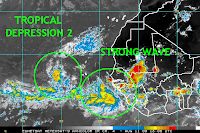


Tropical Depression Two is continuing westward with little change in strength or organization. Sea surface temperatures will remain only marginally favorable for intensification until TD2 reaches 50W, where temperatures begin to warm. Moderate easterly shear is also in place, which is keeping the circulation partially exposed on the eastern side. The model consensus keeps TD2 on a general WNW path into the western Atlantic with little change in intensity through the period. There is a modest chance that the depression will not survive the trek across the Atlantic. The picture will become clearer over the coming day and we'll still have plenty of time to watch it thereafter.
The tropical wave approaching the Lesser Antilles (near 50W) is flaring with convection this afternoon, but there are no signs of organization. This feature should continue to be monitored as a couple models take it into the central/eastern Gulf during the weekend. The ECMWF model, for example, shows a low pressure center forming along the wave axis before moving into the central Gulf Coast next Monday/Tuesday.
Finally, a vigorous tropical wave has just exited the coast of Africa. This is the same wave that the ECMWF and GFS model have been consistently developing into a major hurricane. This afternoon's runs of the CMC, GFS, and ECMWF show much of the same; a strengthening hurricane threatening the eastern Caribbean during the middle of next week. This is a strong model consensus that is hard to ignore. It is also hard to ignore that all models are showing strong high pressure across the central Atlantic, which would keep any developing tropical cyclone on a general westward path over the next 5-8 days. Residents of the Lesser and Greater Antilles are advised to stay updated on TD2 and the aformentioned tropical wave. the medium range forecast is too uncertain to determine what either system will do once it arrives in the eastern Caribbean or western Atlantic.


No comments:
Post a Comment